In early August a vast and mysterious raft of pumice was spotted floating in the South Pacific relatively near New Zealand. Seen first by an aircraft pilot, then by a ship that actually sailed right through it, the pumice was described as two feet thick, about one kilometer wide, and extending sideways as far as the eye could see. An officer on board told Scientific American, “It was like being on an icebreaker hitting an ice shelf.” He described it as the weirdest thing he’d seen in 18 years at sea.
Pumice, a foamy-looking volcanic rock, occurs when lava is subjected to rapid cooling and depressurization. That cooling and depressurization trap gas bubbles inside, making it bouyant. The sighting of volcanic rock in the middle of the sea intrigued Erik Klemetti, assistant professor in the geosciences department and a volcanologist who writes for Wired Science Blogs. He was so intrigued, he decided to take a look himself. “With our world as wired as it is, you’d think you couldn’t hide something as big as an active volcano,” says Klemetti, “but it took two weeks before anyone even noticed.”
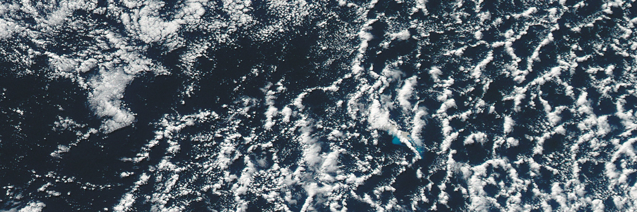
Working with a fellow scientist from NASA, Klemetti examined a month’s worth of satellite imagery from NASA’s Moderate Resolution Imaging Spectroradiometer (MODIS). They discovered the first signs of an underwater eruption—ash-stained water, gray pumice, and a volcanic plume—in imagery taken on July 19. Then Klemetti matched the satellite imagery with ocean floor bathymetry (a topographical map of the ocean floor), and identified Havre Seamount, near the Kermadec Islands, an underwater volcano and the likely source of the eruption and those giant rocks in the ocean.
Klemetti’s work was corroborated by scientists from Tahiti and New Zealand’s GNS Science research services, who connected the eruption with a cluster of earthquakes in the Kermadec Islands on July 17 and 18. Then a scientist from the Université Libre de Bruxelles analyzed nighttime imagery from MODIS and found heat from the eruption at 10:50 p.m. on July 18, 2012, the earliest evidence of the Havre Seamount eruption reaching the ocean surface.
Although the Kermadec Islands are a volcanic island arc, scientists don’t know much about this particular volcano. “In fact,” says Klemetti, “Havre doesn’t even have an entry in the Global Volcanism Program database—heck, it doesn’t even show up on many maps of the active Kermadec volcanoes.” But because of the findings of researchers like him, experts are working to change that.
One cool thing about Klemetti’s detective work is that all the information he used was available to the public. The NASA data and bathymetry charts from the Smithsonian Institution are available online, and one of the tools he used is familiar to most of us — Google Earth.